With XCVario, several speeds are measured :
- True AirSpeed (TAS) can be reconstructed from dynamic pressure & temperature measurements.
- GPS measurement (from FLARM at this stage) gives direct access to Ground Speed (GS)
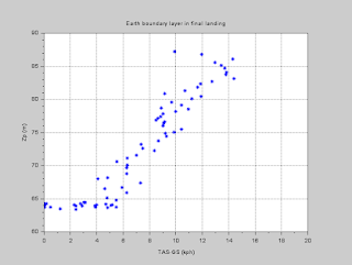
As an illustration for this, the difference between TAS & GS is plotted during final landing phase, representing earth boundary layer above the airfield.
A few observations can be made
- On the 8th of may :
- Both landings show a reclined boundary layer profile, with weaker wind at landing altitude than @ 20m above ground
- On the 2nd landing, wind is stronger & deeper present on the ground
- Gust content is rather low for both landings
- On the 13th of september in St Auban :
- Wind is present almost down to landing altitude, with little reduction of wind component before the last 5m of altitude
- @t~10-12sec, a sensible gust can be observed ~70m above landing altitude, with a "gap" of TAS not visible on GS, and roll activity.
- Another gust is visible @t~30sec, 10m above ground
- A further gust is visible during ground roll -that has been filtered out of wind speed vertical profile
----------------------


Landing on the 8th of may 2021 against "vent d'Autan" with no lift
----------------------


Landing again on the 8th of may 2021 against "vent d'Autan" after a flight in weak distorded lift
----------------------


Landing on the 13th of september 2021 in St Auban
No comments:
Post a Comment